 Preah Vihear is a northern province of Cambodia. Its capital is Phnom Tbeng Meanchey. The province is named after the temple of Prasat Preah Vihear. The first temple on the site was begun in the early 9th century; both then and in the following centuries it was dedicated to Shiva. The earliest surviving parts of the temple, however, date from the Koh Ker period in the early 10th century, when the capital of the Khmer empire was closer than when it was at Angkor. There are also some elements of the Banteay Srei style of the late 10th century, but most of the temple was formed under Suryavarman I and Suryavarman II in the first halves of the 11th and 12th centuries respectively. Due to its location on the border between Cambodia and Thailand, ownership of the area was disputed until June 15, 1962, when the International Court of Justice ruled that the temple belonged to Cambodia — which soon after plunged into civil war. The temple opened briefly to the public in 1992, only to be occupied by the Khmer Rouge the next year. It opened again from the Thai side at the end of 1998, and Cambodia completed the construction of a long-awaited access road in 2003. The temple complex runs 800m along a north-south axis, and consists essentially of a causeway and steps rising up the hill towards the sanctuary, which sits on the cliff top at the southern end of the complex (120m above the northern end of the complex and 525m above the Cambodian plain). Although this structure is very different from the temple mountains found at Angkor, it serves the same purpose as a stylized representation of Mount Meru, the home of the gods. The approach to the sanctuary is punctuated by five gopuras (these are conventionally numbered from the sanctuary outwards, so gopura five is the first to be reached by visitors). Each of the gopuras before the courtyards is reached by a set of steps, and so marks a change in height which increases their impact. The gopuras also block a visitor's view of the next part of the temple until he passes through the gateway, making it impossible to see the complex as a whole from any one point. The fifth gopura, in the Koh Ker style, retains traces of the red paint with which it was once decorated, although the tiled roof has now disappeared. The fourth gopura is later, from the Khleang/Baphuon periods, and has on its southern outer pediment, "one of the masterpieces of Preah Vihear" (Freeman, p. 162): a depiction of the Churning of the Sea of Milk. The third is the largest, and is also flanked by two halls. The sanctuary is reached via two successive courtyards, in the outer of which are two libraries.
Sunday, September 2, 2007
About Preah Vihear
Preah Vihear is a northern province of Cambodia. Its capital is Phnom Tbeng Meanchey. The province is named after the temple of Prasat Preah Vihear. The first temple on the site was begun in the early 9th century; both then and in the following centuries it was dedicated to Shiva. The earliest surviving parts of the temple, however, date from the Koh Ker period in the early 10th century, when the capital of the Khmer empire was closer than when it was at Angkor. There are also some elements of the Banteay Srei style of the late 10th century, but most of the temple was formed under Suryavarman I and Suryavarman II in the first halves of the 11th and 12th centuries respectively. Due to its location on the border between Cambodia and Thailand, ownership of the area was disputed until June 15, 1962, when the International Court of Justice ruled that the temple belonged to Cambodia — which soon after plunged into civil war. The temple opened briefly to the public in 1992, only to be occupied by the Khmer Rouge the next year. It opened again from the Thai side at the end of 1998, and Cambodia completed the construction of a long-awaited access road in 2003. The temple complex runs 800m along a north-south axis, and consists essentially of a causeway and steps rising up the hill towards the sanctuary, which sits on the cliff top at the southern end of the complex (120m above the northern end of the complex and 525m above the Cambodian plain). Although this structure is very different from the temple mountains found at Angkor, it serves the same purpose as a stylized representation of Mount Meru, the home of the gods. The approach to the sanctuary is punctuated by five gopuras (these are conventionally numbered from the sanctuary outwards, so gopura five is the first to be reached by visitors). Each of the gopuras before the courtyards is reached by a set of steps, and so marks a change in height which increases their impact. The gopuras also block a visitor's view of the next part of the temple until he passes through the gateway, making it impossible to see the complex as a whole from any one point. The fifth gopura, in the Koh Ker style, retains traces of the red paint with which it was once decorated, although the tiled roof has now disappeared. The fourth gopura is later, from the Khleang/Baphuon periods, and has on its southern outer pediment, "one of the masterpieces of Preah Vihear" (Freeman, p. 162): a depiction of the Churning of the Sea of Milk. The third is the largest, and is also flanked by two halls. The sanctuary is reached via two successive courtyards, in the outer of which are two libraries.Preah Vihear Statistics
 Preah Vihear is a northern province of Cambodia. Its capital is Phnom Tbeng Meanchey.
The province is named after the temple of Prasat Preah Vihear.
Administration
The province is subdivided into 7 districts.
1301 Chey Saen
1302 Chhaeb
1303 Choam Khsant
1304 Kuleaen
1305 Rovieng
1306 Sangkom Thmei
1307 Tbaeng Meanchey
Location
Preah Vihear Temple is located in a pleasant environment with an attractive country side slightly east of the mid section of the Dongrek Mountains. It is perched on the edge of a giant cliff, about 625 meters above sea level in Preah Vihear Province, Northern part of Cambodia, 625km from the capital city of Phnom Penh. It is also situated close to the Cambodia-Thai border.
 side slightly east of the mid section of the Dongrek Mountains. It is perched on the edge of a giant cliff, about 625 meters above sea level in Preah Vihear Province, Northern part of Cambodia, 625km from the capital city of Phnom Penh. It is also situated close to the Cambodia-Thai border.
What can seen in Preah Vihear Temple
The temple has four levels and four courtyards which comprise of five Gopuras ( entrance pavilions some times surmounted by tower )
The temple has four levels and four courtyards which comprise of five Gopuras ( entrance pavilions some times surmounted by tower )
Palace Building or Gopuras on the third level.

This group of building was the King’s residence when he came to pay homage to the mighty God , and the two wings were the shelters for the pilgrims. The main temple are used for the high-ranking supreme divinities, this mighty group of building is considered as the center of the whole temple complex.
The front stone stairway : this main passage is on the North side. The stairway is 8 meters wide and 78 meters long,. The fist flight has 162 steps. At the first landing is a large stone singa statue on stone block. Another 54 flight of steps 4 meters wide and 27 meters long leads up to the second landing also decorated with stone signa statue.
The Nagaraj Courtyard : this stone-paved is 7 meters wide by 31.8 meters long. From here the stairway leads up to the first-level Gropura. The Stairheads are in the form of seven-headed snakes called "Ngu Suang " facing North towards the Prasat. The heads and tails of nagas on both sides look like ordinary snakes, characterizing and early example of this type of animal figures. The head portion of the naga on the west side looks very impressive because it is made from a single solid stone.
The first level Gopura : this is a pavilion in Greek architecture style with cross plan on an elevated, rebates angle base on each of the roof doorway . Stone lions are placed on each of the roofs dooeway.
Accessibility to the Temple
 The temple can be reached by crossing the Cambodia-Thai gateway border from the Ubon Ratchantani Province of Thailand. Currently the visits are from 8.00 till 16.00 hours.The Grandeur of its site
For all the grandeur of its site, perched on the edge of a giant cliff and with a commanding view over northern Cambodia, Preah Vihear is difficult to visualize as a whole. The experience is truly a memorable one – the series of ascents over the best part of a kilometer, the ornate Gopuras and the wealth of decorative detail truly staggers one’s imagination.
Preah Khan, Kompong Svay
Location, Phum Ta Seng, Khum Ta Seng, Srok Sangkhum Thmei, Khet Preah Vihear,  Cambodia

 Cambodia
Located some 105 kilometres from the main provincial town Tbeng Meanchey, close to the borders with Siem Reap and Kompong Thom Provinces, Preah Khan dates from the reign of Suryavarman I (1002-1050). It comprises a fort within a fort surrounded by extensive walls, a moat and a large baray system containing crocodiles and large fish. Access via National Highway 66 and National Highway 12 is difficult and due to its isolation the structure has already suffered considerable damage at the hands of looters.
Preah Khan is a temple at Angkor, Cambodia, built in the 12th century for King Jayavarman VII. It is located northeast of Angkor Thom and just west of the Jayatataka baray, with which it was associated. It was the centre of a substantial organisation, with almost 100,000 officials and servants. The temple is flat in design, with a basic plan of successive rectangular galleries around a Buddhist sanctuary complicated by Hindu satellite temples and numerous later additions. Like the nearby Ta Prohm, Preah Khan has been left largely unrestored, with numerous trees and other vegetation growing among the ruins.
Preah Khan was built on the site of Jayavarman VII's victory over the invading Chams in 1181. Unusually the modern name, meaning "holy sword", is derived from the meaning of the original — Nagara Jayasri (holy city of victory).[1] The site may previously have been occupied by the royal palaces of Yasovarman II and Tribhuvanadityavarman.[2] The temple's foundation stela has provided considerable information about the history and administration of the site: the main image, of the boddhisatva Avalokitesvara in the form of the king's father, was dedicated in 1191 (the king's mother had earlier been commemorated in the same way at Ta Prohm). 430 other deities also had shrines on the site, each of which received an allotment of food, clothing, perfume and even mosquito nets;[3] the temple's wealth included gold, silver, gems, 112,300 pearls and a cow with gilded horns.[4] The institution combined the roles of city, temple and Buddhist university: there were 97,840 attendants and servants, including 1000 dancers[5] and 1000 teachers.[6]
The temple is still largely unrestored: the initial clearing was from 1927 to 1932, and partial anastylosis was carried out in 1939. Since then free-standing statues have been removed for safe-keeping, and there has been further consolidation and restoration work. Throughout, the conservators have attempted to balance restoration and maintenance of the wild condition in which the temple was discovered: one of them, Maurice Glaize, wrote that;
Preah Khan is northeast of Angkor Thom.
The temple was previously overrun with a particularly voracious vegetation and quite ruined, presenting only chaos. Clearing works were undertaken with a constant respect for the large trees which give the composition a pleasing presentation without constituting any immediate danger. At the same time, some partial anastylosis has revived various buildings found in a sufficient state of preservation and presenting some special interest in their architecture or decoration.[7]
Since 1991, the site has been maintained by the World Monuments Fund. It has continued the cautious approach to restoration, believing that to go further would involve too much guesswork, and prefers to respect the ruined nature of the temple. One of its members has said, "We're basically running a glorified maintenance program. We're not prepared to falsify history".[8] It has therefore limited itself primarily to stabilisation work on the fourth eastern gopura, the House of Fire and the Hall of Dancers.[9]
The site

The outer wall of Preah Khan is of laterite, and bears 72 garudas holding nagas, at 50 m intervals. Surrounded by a moat, it measures 800 by 700 m and encloses an area of 56 hectares (138 acres). To the east of Preah Khan is a landing stage on the edge of the Jayatataka baray, now dry, which measured 3.5 by 0.9 km. This also allowed access to the temple of Neak Pean in the centre of the baray. As usual Preah Khan is orientated toward the east, so this was the main entrance, but there are others at each of the cardinal points. Each entrance has a causeway over the moat with naga-carrying devas and asuras similar to those at Angkor Thom; Glaize considered this an indication that the city element of Preah Khan was more significant than those of Ta Prohm or Banteay Kdei.[10]
Halfway along the path leading to the third enclosure, on the north side, is a House of Fire (or Dharmasala) similar to Ta Prohm's. The remainder of the fourth enclosure, now forested, was originally occupied by the city; as this was built of perishable materials it has not survived. The third enclosure wall is 200 by 175 m. In front of the third gopura is a cruciform terrace. The gopura itself is on a large scale, with three towers in the centre and two flanking pavilions. Between the southern two towers were two celebrated silk-cotton trees, of which Glaize wrote, "resting on the vault itself of the gallery, [they] frame its openings and brace the stones in substitute for pillars in a caprice of nature that is as fantastic as it is perilous."[11] One of the trees is now dead, although the roots have been left in place. The trees may need to be removed to prevent their damaging the structure.[12] On the far side of the temple, the third western gopura has pediments of a chess game and the Battle of Lanka, and two guardian dvarapalas to the west.
Halfway along the path leading to the third enclosure, on the north side, is a House of Fire (or Dharmasala) similar to Ta Prohm's. The remainder of the fourth enclosure, now forested, was originally occupied by the city; as this was built of perishable materials it has not survived. The third enclosure wall is 200 by 175 m. In front of the third gopura is a cruciform terrace. The gopura itself is on a large scale, with three towers in the centre and two flanking pavilions. Between the southern two towers were two celebrated silk-cotton trees, of which Glaize wrote, "resting on the vault itself of the gallery, [they] frame its openings and brace the stones in substitute for pillars in a caprice of nature that is as fantastic as it is perilous."[11] One of the trees is now dead, although the roots have been left in place. The trees may need to be removed to prevent their damaging the structure.[12] On the far side of the temple, the third western gopura has pediments of a chess game and the Battle of Lanka, and two guardian dvarapalas to the west.
West of the third eastern gopura, on the main axis is a Hall of Dancers. The walls are decorated with apsaras; Buddha images in niches above them were destroyed in the anti-Buddhist reaction under Jayavarman VIII. North of the Hall of Dancers is a two-storeyed structure with round columns. No other examples of this form survive at Angkor, although there are traces of similar buildings at Ta Prohm and Banteay Kdei. Freeman and Jacques speculate that this may have been a granary.[13] Occupying the rest of the third enclosure are ponds (now dry) in each corner, and satellite temples to the north, south and west. While the main temple was Buddhist, these three are dedicated to Shiva, previous kings and queens, and Vishnu respectively. They are notable chiefly for their pediments: on the northern temple, Vishnu Reclining to the west and the Hindu trinity of Vishnu, Shiva and Brahma to the east; on the western temple, Krishna raising Mount Govardhana to the west.[14]
Connecting the Hall of Dancers and the wall of the second enclosure is a courtyard containing two libraries. The second eastern gopura projects into this courtyard; it is one of the few Angkorian gopuras with significant internal decoration, with garudas on the corners of the cornices. Buddha images on the columns were changed into hermits under Jayavarman VIII.
Between the second enclosure wall (85 by 76 m) and the first enclosure wall (62 by 55 m) on the eastern side is a row of later additions which impede access and hide some of the original decoration. The first enclosure is, as Glaize said, similarly, "choked with more or less ruined buildings".[15] The enclosure is divided into four parts by a cruciform gallery, each part almost filled by these later irregular additions. The walls of this gallery, and the interior of the central sanctuary, are covered with holes for the fixing of bronze plates which would originally have covered them and the outside of the sanctuary — 1500 tonnes was used to decorate the whole temple.[16] At the centre of the temple, in place of the original statue of Lokesvara, is a stupa built several centuries after the temple's initial construction.
Khmer Empire
The Khmer Empire was the largest continuous empire of South East  Asia, based in what is now Cambodia. The empire, which seceded from the kingdom of Chenla, at times ruled over or vassalised parts of modern-day Laos, Thailand and Vietnam. During the formation of the empire, the empire had intensive cultural, political, and trade relations with Java, and later with the Srivijaya empire that lay beyond the Khmer state's southern border. Its greatest legacy is Angkor, which was the capital during the empire's zenith. Angkor bears testimony to the Khmer empire's immense power and wealth, and the variety of belief systems that it patronised over time. The empire's official religions included Hinduism and Mahayana Buddhism, until Theravada Buddhism prevailed after its introduction from Sri Lanka in the 13th century. Satellite imaging reveals Angkor to have been the largest pre-industrial urban center in the world, larger than modern-day New York.
The history of Angkor as the central area of settlement of the historical kingdom of Kambuja is also the history of the Khmer people from the 9th to the 15th centuries.
From Kambuja itself - and so also from the Angkor region - no written records have survived other than stone inscriptions. Therefore the current knowledge of the historical Khmer civilization is derived primarily from:
archaeological excavation, reconstruction and investigation
inscriptions on stela and on stones in the temples, which report on the political and religious deeds of the kings
reliefs in a series of temple walls with depictions of military marches, life in the palace, market scenes and the everyday lives of the population
reports and chronicles of Chinese diplomats, traders and travellers.
The era of the Khmer kingdom of Angkor started around 800 A. D., when King Jayavarman II married into a local ruling family of that place.
History
Jayavarman II - the founder of Khmer Empire
Jayavarman II (reigned AD 802 to 850), lived as a prince at the court of Sailendra dynasty in Java (Indonesia), whether he lived there as a prisoner or for his education (or both) has not yet been established. He was probably influenced by the refined art and culture of Javan Sailendra, including adoption of the concept of divine Dewa-Raja (God-King) which was prominent during the Sailendra dynasty. In 802 he returned to Cambodia and declared himself the God-King Jayavarman II and declared full independence from Java. This record has given rise to speculation that Cambodia might have been the dependent vassal of Java for some years before the reign of Jayavarman II.
There is speculation that Jayavarman II was probably linked to a legendary king called Jayavarman Ibis, known from the inscriptions K. 103 (dated 20th April 770) and K. 134 (dated 781) who finally settled in the Angkor region, marrying into a local ruling family, what can be corroborated by the inscriptions of Preah Ko (K. 713, dated Monday, 25th January 880), Bakong (K. 826, dated 881/82) and Lolei (K. 324, dated Sunday, 8th July 893). All other information about this king, including the date of his accession, is late and legendary, taken mainly from the Sdok Kak Thom inscription (K. 235, dated 8th February 1053.
Yasodharapura - the first city of Khmer Empire
Jayavarman II's first three successors were also only known from the inscriptions. Indravarman I (reigned A.D. 877 - 889) managed to expand the kingdom without wars, and he began extensive building projects, thanks to the wealth gained through trade and agriculture. Foremost were the temple of Preah Ko, dedicated on Monday, 25th January 880 and irrigation works. He was followed by his son Yasovarman I (reigned A.D. 889 - c. 910), who established a new capital, Yasodharapura - the first city of Angkor.
The city's central temple was built on Phnom Bakheng (Sanskrit: Hemadri), a hill which rises around 60 m above the plain on which Angkor sits. Under Yasovarman I the East Baray was also created, a massive water reservoir measuring roughly 7.5 by 1.8 km.
A 12 or 13th century relief at the Bayon temple in Angkor depicts the Khmer army going to war against the Cham.
At the beginning of the 10th century the kingdom split. Jayavarman IV established a new capital at Koh Ker, some 100 km northeast of Angkor. Only with Rajendravarman II (reigned A.D. 944 - 968) was the royal palace returned to Yasodharapura. He took up again the extensive building schemes of the earlier kings and established a series of temples in the Angkor area, notably Pre Rup and the East Mebon, on an island in the middle of the East Baray (dedicated on the 28th January 953), and several Buddhist temples and monasteries. In 950 the first war took place between Kambuja and the kingdom of Champa to the east (in the modern central Vietnam).
From A.D. 968 to c. 1001 the son of Rajendravarman II, Jayavarman V, reigned. After he had established himself as the new king over the other princes, his rule was a largely peaceful period, marked by prosperity and cultural flowering. He established a new capital near Yashodharapura, Jayenanagari. At the court of Jayavarman V lived philosophers, scholars and artists. New temples were also established: the most important of these are Banteay Srei, considered one of the most beautiful and artistic of Angkor, and Ta Keo, the first temple of Angkor built completely of sandstone.
After the death of Jayavarman V, a decade of conflict followed. Kings reigned only for a few years, and were successively violently replaced by their successors until eventually Suryavarman I (reigned A.D. 1002 - 1049) gained the throne after a long war against his rival king Jayaviravarman (A.D. 1002 - c. 1017). His rule was marked by repeated attempts by his opponents to overthrow him and by military conquests. In the west he extended the kingdom to the modern city of Lopburi in Thailand, in the south to the Kra Isthmus. At Angkor, construction of the West Baray began under Suryavarman I, the second and even larger {8 by 2.2 km) water reservoir after the Eastern Baray.
Suryavarman II
The 11th century was a time of conflict and brutal power struggles. Only with Suryavarman II (reigned 1113 - after 1145) was the kingdom united internally and extended externally. As this king was a staunch Saivite, it seems impossible that he was the builder of the temple of Angkor Wat (Sanskrit: Vishnuloka) because it was dedicated to the god Vishnu. Suryavarman II conquered the Mon kingdom of Haripunjaya to the west (in today's central Thailand), and the area further west to the border with the kingdom of Bagan (modern Burma), in the south further parts of the Malay peninsula down to the kingdom of Grahi (corresponding roughly to the modern Thai province of Nakhon Si Thammarat, in the east several provinces of Champa and the countries in the north as far as the southern border of modern Laos. Suryavarman II's end is unclear. The last inscription, which mentions his name in connection with a planned invasion of Vietnam, is dated Wednesday, 17th October 1145. He probably died during a military expedition between 1145 and 1150, which weakened the kingdom considerably.
There followed another period of disturbances in which kings reigned briefly and were violently overthrown by rebellions or wars. Finally in 1177 Kambuja was defeated in a naval battle on the Tonle Sap lake by the army of the Chams, and was incorporated as a province of Champa.
Jayavarman VII - Angkor Thom
French map of Cambodia under Jayavarman VII.
The future king Jayavarman VII (reigned 1181-after 1206) was already a military leader as prince under previous kings. After the Cham had conquered Angkor, he gathered an army and regained the capital, Yasodharapura. In 1181 he ascended the throne and continued the war against the neighbouring eastern kingdom for a further 22 years, until the Khmer defeated Champa in 1203 and conquered large parts of its territory. Jayavarman VII stands as the last of the great kings of Angkor, not only because of the successful war against the Cham, but also because he was no tyrannical ruler in the manner of his immediate predecessors, because he unified the empire, and above all because of the building projects carried out under his rule. The new capital now called Angkor Thom (literally: "Great City") was built. In the centre, the king (himself a follower of Mahayana Buddhism) had constructed as the state temple the Bayon, with its towers bearing faces which very often wrongly were identified with those of the boddhisattva Lokeshvara (Avalokiteshvara); They are each several metres high, carved out of stone. Further important temples built under Jayavarman VII were Ta Prohm (Rājavihāra), Banteay Kdei and Neak Pean, and the reservoir of Srah Srang. Alongside, an extensive network of streets was laid down, which connected every town of the empire. Beside these streets 121 rest-houses were built for traders, officials and travellers. Not least of all, he established 102 hospitals.
Zhou Daguan - the last blooming
The history of the kingdom after Jayavarman VII is very unclear. In the year 1220 the Khmer withdrew from many of the provinces previously conquered from Champa. One of the successors of Jayavarman VII, Indravarman II, died in 1243. In the west, his Thai subjects rebelled, established the first Thai kingdom at Sukhothai and pushed back the Khmer. In the following 200 years, the Thais would become the chief rivals of Kambuja. Indravarman II was probably succeeded by Jayavarman VIII (reigned 1243 or 1267 - 1295). During the dark 13th century also most of the Buddha statues in the empire (archaeologists estimate the number at over 10,000, of which few traces remain) were destroyed and converted Buddhist temples to Hindu temples. In the same period the construction of the Angkor Wat probably took place, built by a king of whom only his posthumous name Paramavishnuloka is known. From the outside, the empire was threatened in 1283 by the Mongols under Kublai Khan's general Sagatu. The king avoided war with his powerful opponent, who at this time ruled over all China, by paying annual tribute to him. Jayavarman VIII's rule ended in 1295 when he was deposed by his son-in-law Srindravarman (reigned 1295-1308). The new king was a follower of Theravada Buddhism, a school of Buddhism which had arrived in southeast Asia from Sri Lanka and subsequently spread through most of the region.
In August of 1296, the Chinese diplomat Zhou Daguan arrived at Angkor, and remained at the court of King Srindravarman until July 1297. He was neither the first nor the last Chinese representative to visit Kambuja. However, his stay is notable because Zhou Daguan later wrote a detailed report on life in Angkor. His portrayal is today one of the most important sources of understanding of historical Angkor. Alongside descriptions of several great temples (the Bayon, the Baphuon, Angkor Wat), for which we have him to thank for the knowledge that the towers of the Bayon were once covered in gold), the text also offers valuable information on the everyday life and the habits of the inhabitants of Angkor.
Decline and the end of the Angkorean Empire
There are few historical records from the time following Srindravarman's reign. There is only an inscription on a pillar which mentioned the accession of a king in the year 1327 or 1267. No further large temples were established. Historians suspect a connection with the kings' adoption of Theravada Buddhism: there was no need to erect huge temples to them, or rather to the gods under whose protection they stood. The western neighbour of the Empire, the first Thai kingdom of Sukhothai, was conquered by another Thai kingdom, Ayutthaya, in 1350. After 1352 there were several assaults on Kambuja, although these were repelled. In 1431, however, the superiority of Ayutthaya was too great, and, according the Thai chronicles, the Thai army conquered Angkor.
The centre of the residual Khmer kingdom was in the south, in the region of today's Phnom Penh. However, there are indications that Angkor was not completely abandoned. One line of Khmer kings would have remained there, while a second moved to Phnom Penh to establish a parallel kingdom. The final fall of Angkor would then be due to the transfer of economic - and therewith political - significance, as Phnom Penh became an important trade centre on the Mekong. Costly construction projects and conflicts over power between the royal family sealed the end of the Khmer empire.
The nature of the massive water reservoirs or baray surrounding the temples at Angkor has been a major issue of controversy for decades among scholars. Some believe that the baray were central to the Angkorean economy because they were used to store water to secure a steady supply of water to irrigate rice fields. Thus the baray were vital to sustaining the population of Angkor. When the baray became full of silt due to poor maintenance, the population at Angkor could no longer be sustained which eventually led to the abandonment of the temple site at Angkor in favour of Phnom Penh and the decline of the Angkorean Empire. This theory is known as the hydraulic paradigm. However, recent research by W. J. Van Liere and Robert Acker suggests that the baray could not have been used for large scale irrigation. Some researchers, including Milton Osborne, has suggested that the baray may have been symbolic in nature, representing the ocean surrounding Mount Meru thus fulfilling the Hindu mythological cosmos which the Khmer God Kings attempted to recreate on earth as a sign of their relationship with the Hindu gods.
Research continues in favour of confirming and rejecting the hydraulic paradigm. One such research project is The Greater Angkor Project [1]. Researchers working on this project believe that the Khmer had an elaborate system of reservoirs and canals used for trade, travel and irrigation. The canals were used for the harvesting of rice. As the population grew there was more strain on the water system. Failures include water shortage and flooding. To adapt to the growing population, trees were cut down from the Kulen hills and cleared out for more rice fields. That created rain runoff carrying sediment to the canal network. Any damage to the water system would have enormous consequences. 1
In any event, there is evidence for a further period of use for Angkor Wat. King Ang Chand (reigned 1530-1566 ordered the covering of two hitherto unfilled galleries of that temple with scenes from the Ramayana. Under the rule of king Barom Reachea I (reigned 1566 - 1576), who temporarily succeeded in driving back the Thai, the royal court was briefly returned to Angkor. From the 17th century there are inscriptions which testify to Japanese settlements alongside those of the remaining Khmer. The best-known tells of Ukondafu Kazufusa, who celebrated the Khmer New Year there in 1632.
 Asia, based in what is now Cambodia. The empire, which seceded from the kingdom of Chenla, at times ruled over or vassalised parts of modern-day Laos, Thailand and Vietnam. During the formation of the empire, the empire had intensive cultural, political, and trade relations with Java, and later with the Srivijaya empire that lay beyond the Khmer state's southern border. Its greatest legacy is Angkor, which was the capital during the empire's zenith. Angkor bears testimony to the Khmer empire's immense power and wealth, and the variety of belief systems that it patronised over time. The empire's official religions included Hinduism and Mahayana Buddhism, until Theravada Buddhism prevailed after its introduction from Sri Lanka in the 13th century. Satellite imaging reveals Angkor to have been the largest pre-industrial urban center in the world, larger than modern-day New York.
The history of Angkor as the central area of settlement of the historical kingdom of Kambuja is also the history of the Khmer people from the 9th to the 15th centuries.
From Kambuja itself - and so also from the Angkor region - no written records have survived other than stone inscriptions. Therefore the current knowledge of the historical Khmer civilization is derived primarily from:
archaeological excavation, reconstruction and investigation
inscriptions on stela and on stones in the temples, which report on the political and religious deeds of the kings
reliefs in a series of temple walls with depictions of military marches, life in the palace, market scenes and the everyday lives of the population
reports and chronicles of Chinese diplomats, traders and travellers.
The era of the Khmer kingdom of Angkor started around 800 A. D., when King Jayavarman II married into a local ruling family of that place.
History
Jayavarman II - the founder of Khmer Empire
Jayavarman II (reigned AD 802 to 850), lived as a prince at the court of Sailendra dynasty in Java (Indonesia), whether he lived there as a prisoner or for his education (or both) has not yet been established. He was probably influenced by the refined art and culture of Javan Sailendra, including adoption of the concept of divine Dewa-Raja (God-King) which was prominent during the Sailendra dynasty. In 802 he returned to Cambodia and declared himself the God-King Jayavarman II and declared full independence from Java. This record has given rise to speculation that Cambodia might have been the dependent vassal of Java for some years before the reign of Jayavarman II.
There is speculation that Jayavarman II was probably linked to a legendary king called Jayavarman Ibis, known from the inscriptions K. 103 (dated 20th April 770) and K. 134 (dated 781) who finally settled in the Angkor region, marrying into a local ruling family, what can be corroborated by the inscriptions of Preah Ko (K. 713, dated Monday, 25th January 880), Bakong (K. 826, dated 881/82) and Lolei (K. 324, dated Sunday, 8th July 893). All other information about this king, including the date of his accession, is late and legendary, taken mainly from the Sdok Kak Thom inscription (K. 235, dated 8th February 1053.
Yasodharapura - the first city of Khmer Empire
Jayavarman II's first three successors were also only known from the inscriptions. Indravarman I (reigned A.D. 877 - 889) managed to expand the kingdom without wars, and he began extensive building projects, thanks to the wealth gained through trade and agriculture. Foremost were the temple of Preah Ko, dedicated on Monday, 25th January 880 and irrigation works. He was followed by his son Yasovarman I (reigned A.D. 889 - c. 910), who established a new capital, Yasodharapura - the first city of Angkor.
The city's central temple was built on Phnom Bakheng (Sanskrit: Hemadri), a hill which rises around 60 m above the plain on which Angkor sits. Under Yasovarman I the East Baray was also created, a massive water reservoir measuring roughly 7.5 by 1.8 km.
A 12 or 13th century relief at the Bayon temple in Angkor depicts the Khmer army going to war against the Cham.
At the beginning of the 10th century the kingdom split. Jayavarman IV established a new capital at Koh Ker, some 100 km northeast of Angkor. Only with Rajendravarman II (reigned A.D. 944 - 968) was the royal palace returned to Yasodharapura. He took up again the extensive building schemes of the earlier kings and established a series of temples in the Angkor area, notably Pre Rup and the East Mebon, on an island in the middle of the East Baray (dedicated on the 28th January 953), and several Buddhist temples and monasteries. In 950 the first war took place between Kambuja and the kingdom of Champa to the east (in the modern central Vietnam).
From A.D. 968 to c. 1001 the son of Rajendravarman II, Jayavarman V, reigned. After he had established himself as the new king over the other princes, his rule was a largely peaceful period, marked by prosperity and cultural flowering. He established a new capital near Yashodharapura, Jayenanagari. At the court of Jayavarman V lived philosophers, scholars and artists. New temples were also established: the most important of these are Banteay Srei, considered one of the most beautiful and artistic of Angkor, and Ta Keo, the first temple of Angkor built completely of sandstone.
After the death of Jayavarman V, a decade of conflict followed. Kings reigned only for a few years, and were successively violently replaced by their successors until eventually Suryavarman I (reigned A.D. 1002 - 1049) gained the throne after a long war against his rival king Jayaviravarman (A.D. 1002 - c. 1017). His rule was marked by repeated attempts by his opponents to overthrow him and by military conquests. In the west he extended the kingdom to the modern city of Lopburi in Thailand, in the south to the Kra Isthmus. At Angkor, construction of the West Baray began under Suryavarman I, the second and even larger {8 by 2.2 km) water reservoir after the Eastern Baray.
Suryavarman II

The 11th century was a time of conflict and brutal power struggles. Only with Suryavarman II (reigned 1113 - after 1145) was the kingdom united internally and extended externally. As this king was a staunch Saivite, it seems impossible that he was the builder of the temple of Angkor Wat (Sanskrit: Vishnuloka) because it was dedicated to the god Vishnu. Suryavarman II conquered the Mon kingdom of Haripunjaya to the west (in today's central Thailand), and the area further west to the border with the kingdom of Bagan (modern Burma), in the south further parts of the Malay peninsula down to the kingdom of Grahi (corresponding roughly to the modern Thai province of Nakhon Si Thammarat, in the east several provinces of Champa and the countries in the north as far as the southern border of modern Laos. Suryavarman II's end is unclear. The last inscription, which mentions his name in connection with a planned invasion of Vietnam, is dated Wednesday, 17th October 1145. He probably died during a military expedition between 1145 and 1150, which weakened the kingdom considerably.
There followed another period of disturbances in which kings reigned briefly and were violently overthrown by rebellions or wars. Finally in 1177 Kambuja was defeated in a naval battle on the Tonle Sap lake by the army of the Chams, and was incorporated as a province of Champa.
Jayavarman VII - Angkor Thom

French map of Cambodia under Jayavarman VII.
The future king Jayavarman VII (reigned 1181-after 1206) was already a military leader as prince under previous kings. After the Cham had conquered Angkor, he gathered an army and regained the capital, Yasodharapura. In 1181 he ascended the throne and continued the war against the neighbouring eastern kingdom for a further 22 years, until the Khmer defeated Champa in 1203 and conquered large parts of its territory. Jayavarman VII stands as the last of the great kings of Angkor, not only because of the successful war against the Cham, but also because he was no tyrannical ruler in the manner of his immediate predecessors, because he unified the empire, and above all because of the building projects carried out under his rule. The new capital now called Angkor Thom (literally: "Great City") was built. In the centre, the king (himself a follower of Mahayana Buddhism) had constructed as the state temple the Bayon, with its towers bearing faces which very often wrongly were identified with those of the boddhisattva Lokeshvara (Avalokiteshvara); They are each several metres high, carved out of stone. Further important temples built under Jayavarman VII were Ta Prohm (Rājavihāra), Banteay Kdei and Neak Pean, and the reservoir of Srah Srang. Alongside, an extensive network of streets was laid down, which connected every town of the empire. Beside these streets 121 rest-houses were built for traders, officials and travellers. Not least of all, he established 102 hospitals.
Zhou Daguan - the last blooming
The history of the kingdom after Jayavarman VII is very unclear. In the year 1220 the Khmer withdrew from many of the provinces previously conquered from Champa. One of the successors of Jayavarman VII, Indravarman II, died in 1243. In the west, his Thai subjects rebelled, established the first Thai kingdom at Sukhothai and pushed back the Khmer. In the following 200 years, the Thais would become the chief rivals of Kambuja. Indravarman II was probably succeeded by Jayavarman VIII (reigned 1243 or 1267 - 1295). During the dark 13th century also most of the Buddha statues in the empire (archaeologists estimate the number at over 10,000, of which few traces remain) were destroyed and converted Buddhist temples to Hindu temples. In the same period the construction of the Angkor Wat probably took place, built by a king of whom only his posthumous name Paramavishnuloka is known. From the outside, the empire was threatened in 1283 by the Mongols under Kublai Khan's general Sagatu. The king avoided war with his powerful opponent, who at this time ruled over all China, by paying annual tribute to him. Jayavarman VIII's rule ended in 1295 when he was deposed by his son-in-law Srindravarman (reigned 1295-1308). The new king was a follower of Theravada Buddhism, a school of Buddhism which had arrived in southeast Asia from Sri Lanka and subsequently spread through most of the region.
In August of 1296, the Chinese diplomat Zhou Daguan arrived at Angkor, and remained at the court of King Srindravarman until July 1297. He was neither the first nor the last Chinese representative to visit Kambuja. However, his stay is notable because Zhou Daguan later wrote a detailed report on life in Angkor. His portrayal is today one of the most important sources of understanding of historical Angkor. Alongside descriptions of several great temples (the Bayon, the Baphuon, Angkor Wat), for which we have him to thank for the knowledge that the towers of the Bayon were once covered in gold), the text also offers valuable information on the everyday life and the habits of the inhabitants of Angkor.
Decline and the end of the Angkorean Empire
There are few historical records from the time following Srindravarman's reign. There is only an inscription on a pillar which mentioned the accession of a king in the year 1327 or 1267. No further large temples were established. Historians suspect a connection with the kings' adoption of Theravada Buddhism: there was no need to erect huge temples to them, or rather to the gods under whose protection they stood. The western neighbour of the Empire, the first Thai kingdom of Sukhothai, was conquered by another Thai kingdom, Ayutthaya, in 1350. After 1352 there were several assaults on Kambuja, although these were repelled. In 1431, however, the superiority of Ayutthaya was too great, and, according the Thai chronicles, the Thai army conquered Angkor.
The centre of the residual Khmer kingdom was in the south, in the region of today's Phnom Penh. However, there are indications that Angkor was not completely abandoned. One line of Khmer kings would have remained there, while a second moved to Phnom Penh to establish a parallel kingdom. The final fall of Angkor would then be due to the transfer of economic - and therewith political - significance, as Phnom Penh became an important trade centre on the Mekong. Costly construction projects and conflicts over power between the royal family sealed the end of the Khmer empire.
The nature of the massive water reservoirs or baray surrounding the temples at Angkor has been a major issue of controversy for decades among scholars. Some believe that the baray were central to the Angkorean economy because they were used to store water to secure a steady supply of water to irrigate rice fields. Thus the baray were vital to sustaining the population of Angkor. When the baray became full of silt due to poor maintenance, the population at Angkor could no longer be sustained which eventually led to the abandonment of the temple site at Angkor in favour of Phnom Penh and the decline of the Angkorean Empire. This theory is known as the hydraulic paradigm. However, recent research by W. J. Van Liere and Robert Acker suggests that the baray could not have been used for large scale irrigation. Some researchers, including Milton Osborne, has suggested that the baray may have been symbolic in nature, representing the ocean surrounding Mount Meru thus fulfilling the Hindu mythological cosmos which the Khmer God Kings attempted to recreate on earth as a sign of their relationship with the Hindu gods.
Research continues in favour of confirming and rejecting the hydraulic paradigm. One such research project is The Greater Angkor Project [1]. Researchers working on this project believe that the Khmer had an elaborate system of reservoirs and canals used for trade, travel and irrigation. The canals were used for the harvesting of rice. As the population grew there was more strain on the water system. Failures include water shortage and flooding. To adapt to the growing population, trees were cut down from the Kulen hills and cleared out for more rice fields. That created rain runoff carrying sediment to the canal network. Any damage to the water system would have enormous consequences. 1
In any event, there is evidence for a further period of use for Angkor Wat. King Ang Chand (reigned 1530-1566 ordered the covering of two hitherto unfilled galleries of that temple with scenes from the Ramayana. Under the rule of king Barom Reachea I (reigned 1566 - 1576), who temporarily succeeded in driving back the Thai, the royal court was briefly returned to Angkor. From the 17th century there are inscriptions which testify to Japanese settlements alongside those of the remaining Khmer. The best-known tells of Ukondafu Kazufusa, who celebrated the Khmer New Year there in 1632.
U.S. supports Cambodia's bid to list Preah Vihear Temple as world heritage site
PHNOM PENH, July 19 (Xinhua) -- The United States has expressed support for Cambodia's bid to officially register the Preah VihearTemple as world heritage site and will provide aid for its development and management plans, local media reported on Thursday.U.S. Ambassador Joseph A. Mussomeli here on Wednesday told Cambodian Deputy Prime Minister and Minister of the Council of Ministers Sok An that the temple has to be officially registered as world heritage site even if there is opposition from the third side, press official for the Council of Ministers Phan Sithan was quoted by English-language newspaper Cambodian Daily as saying. The United States will send a group of experts to Cambodia to help organize the development and management plans for the temple's official registration as world heritage site and also provide grant aid to support the plans, he said.Recently, Long Visalo, deputy minister of foreign affairs and international cooperation, told reporters that the world heritage committee of the United Nation's Education, Science and Culture Organization (UNESCO) asked Cambodia to organize the development and management plans for the Preah Vihear Temple after receiving the kingdom's request to list it as world heritage site.The committee promised to decide whether the temple can be registered as world heritage site in early 2008.The Preah Vihear Temple was built from the 11th to the 12th century on top of the Dorng Rek Mountain in the northern part of Cambodia next to Thailand. Cambodia secured its ownership of the temple in 1962, out of fierce competition with Thailand.
Koh Ker

Phum Srayao, Khum Srayao, Srok Koulen, Khet Preah Vihear, Cambodia
Dating from the early 10th century, the remote Koh Ker group is located some 60 kilometres north east of Angkor and 72 kilometres from the main provincial town, Tbeng Meanchey. It comprises a group of 38 temples, constructed in laterite. Access via National Highway 66 or National Highway 211 is difficult.
U.S. Delegation Visits Preah Vihear Temple

U.S. Delegation Visits Preah Vihear Temple
At the recent meeting of UNESCO's World Heritage Committee in Christchurch, New Zealand, the Committee recognized that "the Sacred Site of the Temple of Preah Vihear is of great international significance and has Outstanding Universal Value" and agreed "in principle" that the temple should be inscribed in the World Heritage List. The Committee also requested that Cambodia strengthen conservation and management at the site by "making progress in developing an appropriate management plan, which progress will enable its formal inscription by the Committee at its 32nd Session in 2008."
The U.S. fully supports the inscription of Preah Vihear on the World Heritage List, and at the request of the Cambodian government, U.S. Ambassador Joseph A. Mussomeli recently traveled to Preah Vihear, along with a representative of the U.S. State Department's Cultural Heritage Center and other Embassy officials, to try to determine how the U.S. Government might be able to support the Royal Government of Cambodia in its efforts to develop a management plan for Preah Vihear. During the visit, Ambassador Mussomeli expressed his appreciation for the exceptional nature of the site and pledged to discuss Preah Vihear with other U.S. Government representatives during an upcoming trip to Washington.
Preah Vihear, dedicated to Shiva, is situated on a promontory of the Dangrek Range, 547m above the Cambodian Plain. The buildings were constructed in the first half of the 11th century AD and form the most important sanctuary built during the reign of King Suryavarman (1002-50), who seized power at Angkor around 1006. The southern extremity of the promontory juts out to form a natural recess that is a sacred place, commanding a vast panorama.
Like many Cambodian monuments, this sanctuary consists of a succession of courtyards on a common axis (though the north-south axis here is somewhat unusual). The axial plan is 800m long in which gopuras (gateway towers) and streets succeed one another on the way to the temple. To the north, a 54m monumental stairway with 159 steps leads to a 25m long pavement flanked by enormous rampant nagas (snakes). From here three steps reach the first of the five gopuras, which eventually leads to the main sanctuary enclosed by two groups of galleries laid out in a cloister form that foreshadows the "cruciform cloisters" of Angkor Wat.
The principal material of all the buildings at Preah Vihear is sandstone from the site itself. The finest decoration is to be found on the gopuras, many of which are in an excellent state of conservation and clearly visible. The composition of the sculptures on the lintels, pillars, pilasters and elsewhere are varied, complex, highly detailed and harmonious, representing Hindu gods and other religious figures such as Shiva, Vishnu, Indra and Krishna.
Source: Embassy News
Saturday, September 1, 2007
Preah Vihear: The border was already settled by The Hague International Court of Justice

Preah Vihear:
The border was already settled by The Hague International Court of Justice
Near the end of June 2007, following Thailand’s reservations, UNESCO decided to “suspend” Cambodia’s request for the protection of the Preah Vihear Temple as a World Heritage site, and the UN body asked the two countries “to quickly resolve the issue of border demarcation at this location.”
In Bangkok, according to the news published on June 29, 2007, Thailand’s Ministry of Foreign Affairs issued the following statement: “In principle, Thailand totally agrees that the Preah Vihear Temple should be listed as a UNESCO World Heritage site, under the reservation that the differences on the site’s joint management and the problems of border demarcation are resolved first.” Immediately after this statement, Thailand sent its “black-clad uniformed” troops to prevent the access to the temple from the Thai side, and to close the border. These actions effectively created unease and excitation on Cambodia’s side.
The action taken by the Thai troops is nothing new when it comes to the Cambodian Preah Vihear Temple. Two years ago, in May 2005, “black-clad” Thai soldiers undertook the same action towards the temple. At the time, Thammarak Isarangura, the Thai Minister of Defense, declared that “Thai troops would remain (there) to assure that there will not be any crossings into the territories in conflict, until the two countries complete their demarcation work.” In Phnom Penh, Thailand’s ambassador to Cambodia declared that Thailand intends to respect the decision of The Hague International Court of Justice which gave the ownership of the Preah Vihear Temple to Cambodia in 1962. “However, the decision concerned the temple only and it did not precise the border delineation … That’s why this problem persists until nowadays.” On July 06, 2007, Viraphand Vacharathit, Thailand’s ambassador in Phnom Penh, implicitly placed the blame on Hun Sen’s government when he declared to the news media that “Cambodia knew very well that UNESCO would suspend this decision on Preah Vihear … because of the absence of the border demarcation line…”
In 2005, Hun Sen’s government promised to “resolve this problem of border delineation as soon as possible.” Now, Khieu Kanharith, the Minister of Information and spokesman of the government, vaguely said that “some small technical problems still remain to be resolved, regarding the new housing constructions, radio [broadcast] towers, irrigation canals, etc…” On the other hand, Va Kim Hong, the government minister in charge of border issues who is even more confused that his ministry of information colleague, let it be known that there would not be “any problem left for anyone, (because) the local authorities, the Preah Vihear provincial authorities, and our local people just have to present to us their problems, and we will resolve them together.”
The issue questioned by UNESCO involves the resolution of the so-called “white zone” located in front of Preah Vihear, a zone which Hun Sen’s government admitted its existence in the past few years to the great satisfaction of Thailand, this in spite of the historical stipulations of treaties recognized by both countries since 1907, and in spite of the irrevocable decision rendered by The Hague International Court of Justice in 1962 regarding this temple. In fact The Hague Court’s decision dated June 15, 1962, clearly indicated the prior existence of a border delineation between Thailand and Cambodia at this location, BEFORE the court issued its decision to hand the ownership of the temple to Cambodia (please read the court decision attached). There was no “white zone” and there is nothing to “negotiate” again on the border demarcation in front of the Preah Vihear temple. All that remain are the reference to the maps retained by The Hague International Court of Justice, and the building of the corresponding border demarcation posts. Such operation would be completed within a few weeks.
However, we recall that the existence of these “white zones” was adopted by Hun Sen and his party, the PRPK-CPP (PRPK is the acronym for the People's Revolutionary Party of Kampuchea which was later rechristened to the Cambodian People Party or CPP), following their conclusions on illegal treaties and agreements with Hanoi in the 80s on Cambodia’s new borders. These illegal treaties and agreements, which are perfidiously put into application, have de facto rejected or made obsolete all or part of other international treaties of Cambodia with respect to her territorial integrity. For example, the agreement of the cession by the PRPK-CPP to Hanoi of the islands of Koh Tral and Koh Krachak Seh, and of the so-called “Historical Waters” (a maritime “white zone”) between Vietnam and the People’s Republic of Kampuchea in July 1982, changed the delimitation of the maritime border between Cambodia and Vietnam, and subsequently, the one between Cambodia and Thailand, and it created “white zones” at sea between the two latter countries also. Obviously, these “white zones” later became conflict zones, zones where the law of jungle and instability prevail, and where the first victims are the defenseless and unprotected Cambodian population, this in spite of the confused and irresponsible assurances given by Hun Sen’s government (1).
The note by UNESCO on the imprecision of the border in front of the Preah Vihear Temple – an imprecision based on Thailand’s reservations which completely ignores the decision handed by the International Court of Justice on June 15, 1962 – is a dangerous precedent on the historical rights of Cambodia’s territorial integrity: it is the UNESCO, a UN institution, which accepts, at this location, the existence of a so-called “white zone” between the two countries. What will become of the other “white zones” which were recognized by the Hun Sen’s regime and by his party with Cambodia’s neighbors? By following this path, the entire Cambodia will soon become a “white zone” for Thailand and Vietnam – if it is not one now already – just as it was 200 years ago.
----
(1) During the 1954 Geneva conference, a 1:100,000-scale map produced and kept in France (latest edition) was submitted to the International Control Commission (which was later presided by India under the leadership of Mr. K.L. Bindra), as well as a smaller scale map for ease of use under the circumstance.
On the other hand, between 1968 and 1971, France provided help to Cambodia to establish a 1:200,000-scale geologic map with the participation of 8 French geologists and engineers, as well as 20 other Khmer engineers who performed the works and the research under the direction Mr. Sean Pengse.
At the time, there was no “white zone”.
Paris, July 9, 2007
Vice-President, Cambodia's Border Committee
DY Kareth
Poosted by: Cambodian Information Center
Saturday, August 25, 2007
Preah Vihear dispute
noelbynature July 9th, 2007
06 July 2007 (The Nation) - A dispute about Thai military wearing uniforms on the premises leads to the army closing the entrance to the Angkor temple of Preah Vihear. The 11th century temple is located on Cambodian soil, but the only entrance is through the Thai side of the border.
Mutual ties not affected by Phreah Vihear dispute : Thai ambassador
Thailand’s concerns about unsettled border issues, which resulted in Unesco’s decision to delay Cambodia’s request to list the Phreah Vihear shrine as World Heritage site, will not affect ThailandCambodia relations, said Thai Ambassador to Cambodia Viraphand Vacharathit.
Cambodia understood the Thai position that there were still certain unsettled issues including border demarcation, he said.
Unesco’s World Heritage committee delayed until next year a decision to put the shrine on the World Heritage list. The decision came after Thailand argued that the Thai-Cambodian border has yet to be demarcated and a joint management plan for the area is still being discussed.
The Thai envoy said Cambodia is well aware that its request was not rejected but only delayed until next year’s meeting, While some local Cambodian media wanted to instigate publicity, the majority of the Khmer people including the government understood the matter.
The ambassador reiterated that the Unesco panel based its decision on the basis that it needed more information and related documents concerning Cambodia’s request about Preah Vihear.
The panel asked Cambodia to resubmit its request in February next year.
Meanwhile a senior Thai army officer said the Thai army has closed the entrance to Phreah Vihear, close to Si Sa Ket province, after refusing to abide by a Cambodian order not to wear uniforms when they visit the venue.
The Cambodian side claimed that seeing the Thai military in uniform will not be good for tourism in Preah Vihear.
Monday, August 13, 2007
U.S. supports Cambodia's bid to list Preah Vihear Temple as World Heritage Site
The United States has expressed support for Cambodia's bid to officially register the Preah VihearTemple as world heritage site and will provide aid for its development and management plans, local media reported on Thursday.
U.S. Ambassador Joseph A. Mussomeli here on Wednesday told Cambodian Deputy Prime Minister and Minister of the Council of Ministers Sok An that the temple has to be officially registered as world heritage site even if there is opposition from the third side, press official for the Council of Ministers Phan Sithan was quoted by English-language newspaper Cambodian Daily as saying.
The United States will send a group of experts to Cambodia to help organize the development and management plans for the temple's official registration as world heritage site and also provide grant aid to support the plans, he said.
Recently, Long Visalo, deputy minister of foreign affairs and international cooperation, told reporters that the world heritage committee of the United Nation's Education, Science and Culture Organization (UNESCO) asked Cambodia to organize the development and management plans for the Preah Vihear Temple after receiving the kingdom's request to list it as world heritage site.
The committee promised to decide whether the temple can be registered as world heritage site in early 2008. The Preah Vihear Temple was built from the 11th to the 12th century on top of the Dorng Rek Mountain in the northern part of Cambodia next to Thailand. Cambodia secured its ownership of the temple in 1962, out of fierce competition with Thailand.
Source: Xinhua
Friday, July 13, 2007
Preah Vihear Temple to wait a year for World Heritage Site decision
The United Nations Educational, Scientific and Cultural Organization (UNESCO) World Heritage Committee announced after its annual meeting in New Zealand last week that it has delayed the registration of Preah Vihear temple onto the UNESCO world heritage list to next year, as Cambodia needs to resolve some issues, local media reported on Monday.
The World Heritage Committee needs to consider the Thai demand for clear border markings at the site, and asked the two nations to settle their common problems first, suggesting that Cambodia can again make the request next year, said Cambodian daily newspaper the Rasmei Kampuchea.
Cambodian government spokesman and Information Minister Khieu Kanharith confirmed last Friday the postponement of the Cambodia's request for the temple to be listed as a world heritage site, agreeing that a few technical issues remain to be solved.
However, the minister stressed that the delay was not related to Thailand.
"Thailand didn't oppose the Cambodia's request to register Preah Vihear temple, but we have a few technical problems such as new buildings, radio towers, stalls and drainage (system)," said Kanharith.
Preah Vihear temple, situated along the Cambodian-Thai border, has long been a cause of dispute between the two Kingdoms, with the International Justice Court in 1962 ruling against Thailand's sovereignty claim. Cambodia and Thailand are discussing a joint plan to manage the area.
Source: Xinhua
Subscribe to:
Posts (Atom)


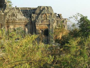

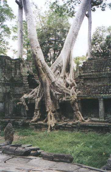
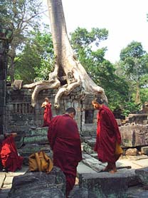

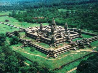

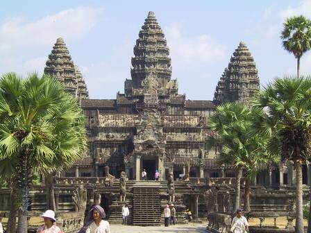
